Apuckawa Birding & hiking Trail
From the stop light in Montello, go East on Hwy 23 .6 of a mile, turn right on Hwy C, go 5.8 miles to a 4-way stop. Continue straight on Fox Ct. Turn right on Toepper Dr to the parking area.
On this .8 of a mile trail starting from the boat landing north through a hardwood forest and remnant prairie, you may be lucky to catch a glimpse of a white squirrel. In a 2011 survey, birders recorded 116 species of birds, including those seen from the boat landing on Lake Puckaway.
French Creek State Wildlife Area
From Montello, take Hwy 22 south 8.2 miles, turn right on Hwy O ang go 2.7 miles. Turn left on 13th Road. Go 1/2 mile to the parking lot or continue to the corner of 13th Rd and 14th Rd for additional parking.
This DNR owned property is a combination of marsh, hardwoods and prairie. Park in the lot at the corner of 13th Rd & 14th Rd and take an easy walk up the hill that overlooks Dates Millpond and the surrounding landscape. The property is abundant with wildlife, and is a favorite of pheasant, turkey and deer hunters.
Grand River Locks
The trail is located at the end of Lower Locks Rd., 3.2 miles south of Montello off of Hwy 22.
Bordering the Fox River, this site has a handicap accessible fishing pier and trail. It’s a great area for bird watching and easy walking.
John Muir County Park
Located 8 miles south of Montello at N1595 County Rd F
John Muir County Park, once known as Fountain Lake Farm, is where the Muir Family built their first home after immigrating to Marquette County from Dunbar, Scotland. A young John Muir, who would later become known as the Father of National Parks, was greatly influenced by this land and tried to purchase it several times throughout his life to preserve it. Visitors may explore the 125-acre park by hiking the trail that circles 30-acre Ennis Lake and passes through 7 different habitats. You can find the wonderful wilderness that he came to love by sauntering the public lands and trails of his boyhood home.
Page Creek State Natural Area
Located 5.9 miles west of Montello on County Rd K.
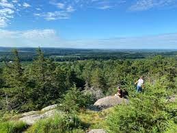
Observatory Hill
From Montello, take County Road F South for about 5 miles; turn left on 14th Rd. Go a half mile to 13th Rd., turn right for 1.4 miles, then left on Gillette Avenue for .6 miles to the parking lot.
This mile-long primitive trail will take you to the highest point in Marquette County for a spectacular panoramic view. The hill is an isolated outcropping of porphyritic rhyolite that rises 300 feet above the surrounding landscape. This volcanic rock has been dated to 1.76 billion years ago and contains grooves created by a glacier over 12,000 years ago.
Neshkoro Pines Trails
It is located behind the ball diamond at Stan-O-Gene Park, just North of Neshkoro on State Hwy 73. The trails range from .75 miles to 1.25 miles long.
Westfield Community Trails
Trailheads start at the North end of Pioneer Memorial Park. The School View Trail is a half mile one way and the East Trail is a third mile the other way. Both are groomed and wide enough to walk side-by-side.